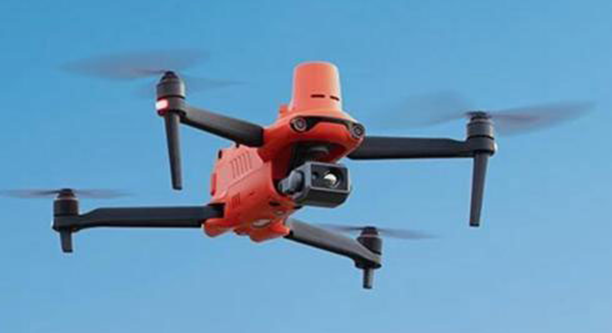
Model: YH II 640T VTK E3 Drone
Suitable for surveying and mapping
Centimeter-level High Precision Positioning
YH II VTK series integrates an VTK module, providing real-time centimeter-level positioning data within three minutes and supporting PPK post-processing. The aircraft can record satellite raw observation data, camera exposure parameters, and other data. The positioning SYstem supports both VTK base stations and network VTK, ensuring precise and stable data collection even in complex environments, empowering various industry applications.
Ultra-Clear Vision, Every Detail in Sharp Focus
YH II VTK E3 is equipped with a 1-inch super-sensitive CMOS sensor with excellent noise reduction capabilities. Even in low-light conditions, it can capture clean and clear 4K video with high ISO.
1-inch Super-Sensitive Sensor
Featuring a 1-inch CMOS image sensor, with a Max pixel count of 20 million pixels, capable of shooting videos up to 6K/30FPS. Thanks to the super-sensitive algorithm, it can capture clean and detailed night scenes with low noise even at high ISO settings.
Adjustable Aperture F2.8~F11
By adjusting the lens aperture size, it adapts to changes in outdoor lighting, presenting more layered and clearer images.
Aircraft
1. Weight (including propellers, battery, and VTK module): 1250g ± 5g
2. Max Takeoff Weight: 1999g
3. Dimensions (length x width x height): 230 x 130 x 143mm (folded)
457 x 558 x 143mm (unfolded)
4. Wheelbase: 397mm
5. Max Takeoff Altitude: 7000m
6. Max Ascent Speed: 8m/s (Sport mode)
7. Max Descent Speed: 4m/s (Sport mode)
8. Max Horizontal Flight Speed: 20m/s (Sport mode)
9. Max Endurance Mileage (no wind): 21 km
10. Max Rotation Angular Velocity: 120°/s
11. Max Tilt Angle: 33° (Sport mode)
12. Longest Flight Time (no wind): 38 minutes
13. Longest Hovering Time (no wind): 32 minutes
14. Working Environment Temperature: -10°C ~ 40°C